Who is leading the way with cotton bush mapping in WA?
Recent activity mapping cotton bush in Western Australia shows coastal regions are leading the way!
The results so far
Over the past four weeks, we have put out the call to citizen scientists and weed watchers to report narrow leaf cotton bush (Gomphocarpus fruticosus) across Western Australia. The first results are in!
In total we have added 133 new points (orange dots) to the cotton bush distribution map. This is an outstanding effort from everyone involved! However, the vast majority of these points have been in the western part of the range between Nannup and Gingin. Outside a single report from Esperance, we have no new reports east of Boraning, despite old records (green and yellow dots) showing cotton bush spread all the way between Perth and Esperance.
Who is going to rise to the challenge and fill in the remaining gaps on the cotton bush map? Who can push our known records east to get the data matching what is really out there? Which biosecurity group, catchment council or keen weed watcher will bring home the trophy for most new records in the coming month?
We’ll provide a further update in a few weeks from now!
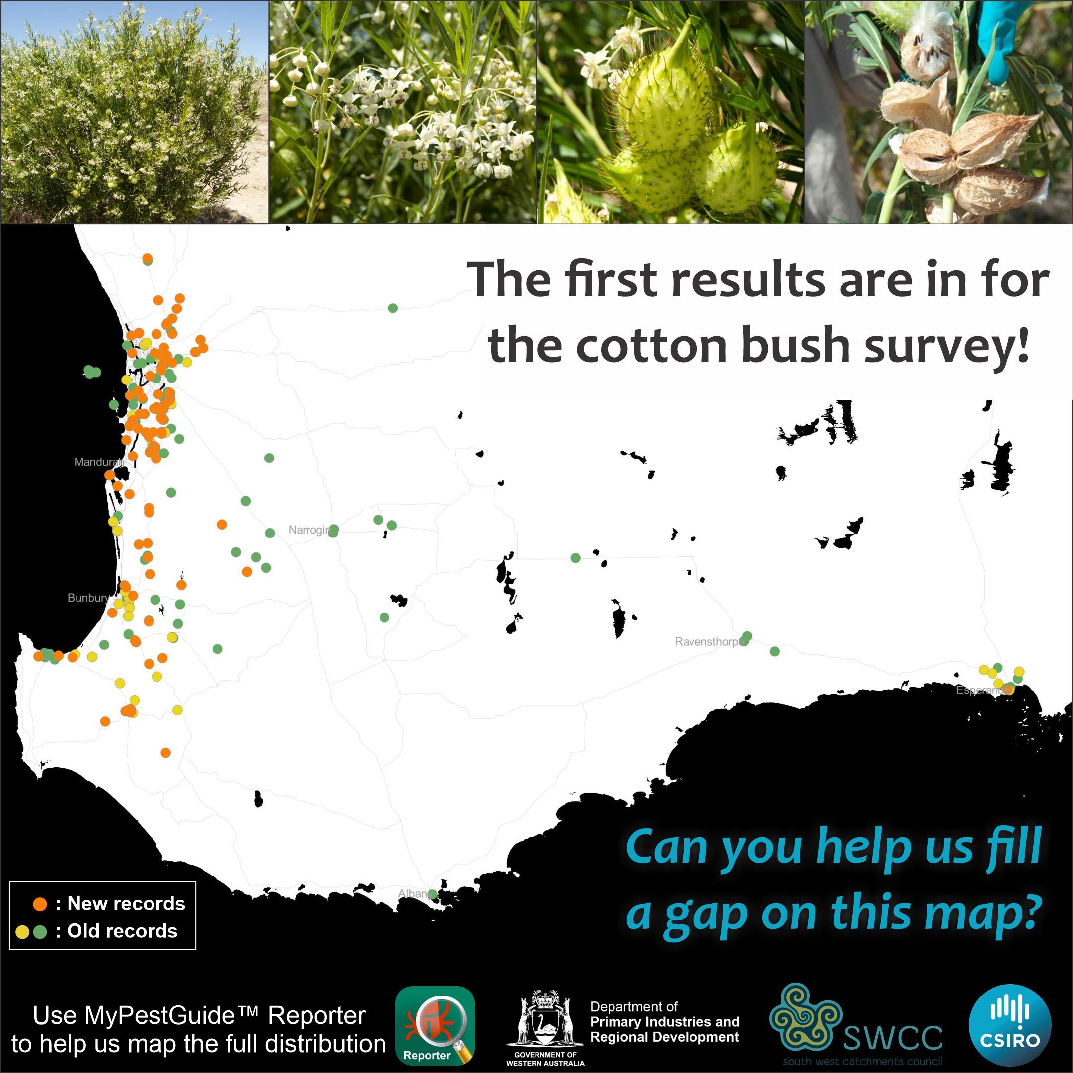
Cotton bush records in Western Australia. New records from the last four weeks (orange) and old records (green and yellow) are shown.
Why are we doing this?
Developing an understanding of how to improve weed management depends significantly on knowing the distribution of the weed of interest. Stakeholders producing management plans frequently rely on online databases, such as the Atlas of Living Australia, to inform their understanding of what weed is where. For many weeds, however, the data recorded in these online repositories is a very poor representation of the true distribution. For those of us working on weed management challenges, it’s a well known fact that people collecting data for the distribution of plants often overlook weedy species.
New collection methods, including app-based tools, are revolutionising our ability to understand which plants are where in the landscape. Anyone with access to these tools and the time to invest can help build a deeper understanding of where weeds are, and what they are doing where they are found. Here’s where we would value your help!
What are we doing?
Our team at CSIRO is collaborating with the South West Catchments Council and a number of community groups to help develop new tools for controlling narrow leaf cotton bush (Gomphocarpus fruticosus) in Western Australia. As part of this work, we need to map the full distribution of this weed, ideally down to every population. We are well aware that the distribution as it is currently recorded on the Atlas of Living Australia is a far cry from the actual distribution across the state.
How you can help!
We would love your help to fill the remaining gaps on our cotton bush map. Here’s what to do!
- Please download DPIRD’s MyPestGuide™ Reporter app to your smartphone.
- Report any cotton bush plants you find, along with any insects or disease that you notice on the plants.
- Send in a sample (details provided in the app) if you notice anything else interesting.
A full step by step set of instructions can be found for download here: [Cotton bush sampling instructions]
Please do not hesitate to get in touch if you would like further information or if you have any questions about our work.
Thanking you all in advance!